
EARLY HISTORY
400 million years ago: The Niagara Escarpment during the Ice Age
1756 - 1831: The Hansler property
1826: The fort that never was
1840's: The naming of Fonthill
1880's: The Township of Pelham
1896: The trains eventually came
1900 - 1920: The Pratt Family Farm
THE NIAGARA ESCARPMENT DURING THE ICE AGE
Over 400 million years ago, the Niagara Escarpment was formed and existed before glaciations. The Escarpment existed before the formation of the Falls of Niagara and prior to the extinction of dinosaurs. The land that is now Southern Ontario emerged from the sea of the Paleozoic Era at least 245 million years ago.
Approximately 23,000 – 12,000 years ago the Niagara Escarpment was covered with a 2 – 3 kilometers thick sheet of ice, known as the “Wisconsin Glacier”. The retreat of the Wisconsin Glacier was the consequence of the Great Lakes surrounding the Niagara Peninsula and the Niagara Falls themselves.
The Fonthill Kame, a Giant Hill Located in Pelham—The Niagara Region’s highest elevation at Fonthill is due to the enormous glacial sand and gravel deposits that make up the Fonthill Kame. It is approximately 6 km east to west, and 3 km north to south. The Kame has considerable influence on the climate of the eastern edge of the Town, sheltering it from the winds from the southwest. This provides good growing conditions for fruit crops, vineyards, and yes, golf courses.

The Niagara Escarpment has seen three ice ages, the last of which ended approximately 14,000 years ago. Erosion from ancient waters and glacial recession in this last ice age carved the Escarpment into what we see today.
1756-1831 - THE HANSLER PROPERTY
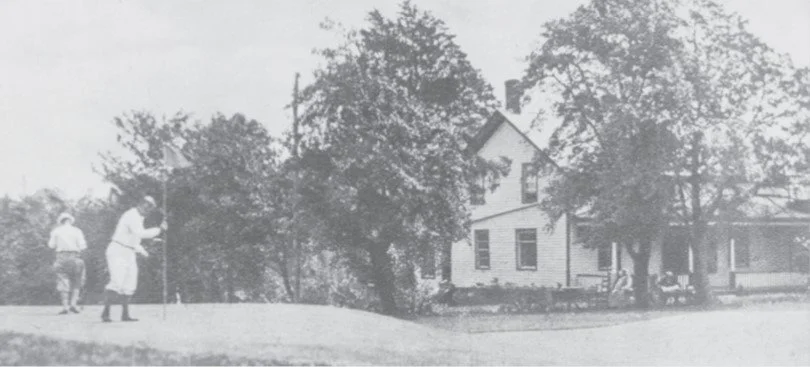
Part of the land that was purchased by Lookout Point in 1920, was once owned by the Hansler family (1756-1831) In 1756, after the American Revolution, Mr. George Hansler left New Jersey to settle on the Twelve-Mile Creek in Thorold. One of George’s sons, Andrew, owned part of the land where the Lookout Point Clubhouse now stands, and westward to Effingham Road. In 1965, the Bissell family developed an adjacent property into a “vacationer’s paradise” known as Bissell’s Hideaway, where for the past 60 years, golfers coming up #14 fairway will often hear the sound of children playing in the natural swimming lake.
Hansler-Scott-Bissell House and Bissell's Hideaway - Pelham Historical Society
Artist rendition of the Hansler-Scott-Bissell House, formerly located on Metler Road, across from #14.
1826 - THE FORT THAT NEVER WAS
The “Lookout Point”—During the War of 1812, the British would send soldiers to the highest point in the Niagara Region to “look out” for movement of troops. After the War of 1812, with ongoing concerns for another American attack, the British Government ordered Colonel E. W. Durnford to design a fort. They purchased 200 acres on the “highest part of the Short Hills” for the fort itself, and had plans to purchase more, for defense purposes. This fort, which would command a view of a large area in the Peninsula, was to be about 2,300 feet in diameter and be capable of sustaining a force of some 2,000 men for a period of 12 full months. By 1827, however, the threat of war had passed, and subsequent financial difficulties experienced in Britain put an end to the purchase of all of the lands which had been designated as essential for the project. No construction of a military nature was ever begun. The 200 acres were sold in parcels between 1860 and 1870.
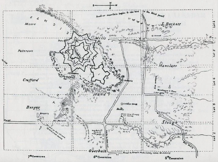
1826 historical plans for a fortress to be built on the north side of Lookout Point (above is a 1938 illustration, original drawings are at the Club).
1840's - THE NAMING OF FONTHILL
Though there is some record of settlement as far back as 1829, the first name “Osborne’s Corners,” was given around 1842, next it was “Temperanceville”, and finally “Fonthill.” In the year 1843, Mr. Henry Giles wrote two letters to his brother Robert. May 17, 1843—“We took a walk a few days since, to Pelham Heights [today’s Lookout Point], about a mile from Hill cottage where we had a most extensive and enchanting prospect including both lakes, St.Catharines and Niagara.” July 15, 1843—“The principal man in the new village wishes to name it Temperanceville, which I tell him is a vile name. There is a large Temperance Hotel at the top of this hill, to which they are about to conduct a stream of water, and construct a fountain. This being the case, I have proposed the name of Fonthill.”
The Early History of Fonthill
Pelham Historical Society
The History of Keith's Restaurant - 1830s-1917
Welland Tribune

1840's Pelham Road, before it turns right onto Hollow Road leading to the Short Hills. Farmhouse on the left was the home of Henry Giles.
1880's - THE TOWNSHIP OF PELHAM
Town of Pelham and Fonthill, Pelham Township—The Township of Pelham was settled initially by Tunkers (Brethren of Christ) and Quakers (Society of Friends), mostly from Pennsylvania, New Jersey and New York. By 1885, with a population of just over 1,000, three main settlements could be found in Pelham Township- Fonthill, Ridgeville and Fenwick. Other smaller communities included Effingham, North Pelham, Pelham Union and Pelham Corners. There were also 1,200 horses, 1,750 sheep, and 2,200 horned cattle in the township at that time.
Pelham Today—Nestled in the heart of the Niagara Region, the Town of Pelham is one of 12 municipalities in the Region. Pelham is primarily an agricultural area where many farms abound. Orchards, tender fruit and grape vineyards are plentiful. With a population of just over 18,000, Pelham embraces technological and urban change while preserving a small-town feel and nostalgia of days gone by.

1876 Historical Atlas for the Counties of Welland and Lincoln.
1896 - THE TRAINS EVENTUALLY CAME TO FONTHILL
In 1896, a railway was completed to link Toronto and Hamilton to the bridge in Buffalo (the T.H.& B.), and by the end of the century, you could get from Fenwick to Welland in 20 minutes, and travel to Hamilton in an hour and a half. In 1905, Fonthill got connected to the Welland Division of the Niagara, St. Catharines and Toronto Railway, running from Fonthill to Thorold, Welland and Port Colborne, or going to Port Dalhousie to connect with the Toronto steamers. For 25 cents in 1945, one could ride return from Fonthill to Port Colborne, with hourly service from the Fonthill Station, 6 a.m. to midnight. The line operated from 1905 until 1959.
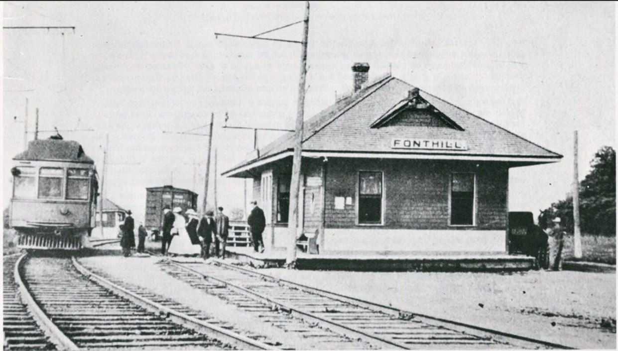
The then-famous Fonthill Station was located on the corner of Hwy 20 and Station Street. Photo is circa 1910.
1900-1920 - THE PRATT FAMILY FARM
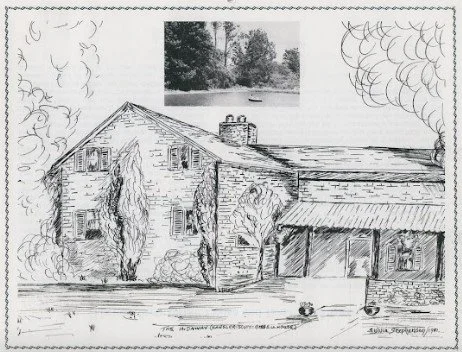
In 1920, Leonard Pratt sold his farm to Lookout Point. For 20 years, the family had farmed stock, grain, potatoes and fruit. They lived in the farmhouse (Lookout Point’s first clubhouse). The Pratt family had 3 daughters and a son. One of the daughters, Ella Carver, was interviewed in 1989 at age 90. “Money wasn’t as plentiful as it is today, and the family had to work at home picking apples, potatoes, and trimming vines. Our farmhouse was located near a running stream, and the water came out of the bank between two flat rocks. It was such a wonderful water supply. That was why they chose our farm for the golf course.”
The Pratt Family Farmhouse became Lookout Point's first clubhouse.